
|
Antares charts |
|
Very Large scale wgs 84 electronic charts |





|
Download printable pdf of 2026 Corrections and Cautions
All Cautions and Amendments will be listed here. For printable versions of each year’s Cautions and Corrections see below.
Corrections to our 2026 charts (please advise us of all issues, big or small, that you spot!):
Correction: AC 5724A Lochcarron Bay, Loch Carron. Lochcarron Moorings Association (LCMA) has laid four moorings for visitors to access local facilities. One is close to shore (off the ‘Post marking large reef’ shown on our chart) where shops, cafes, restaurants, bars and fuel are available, with three closer to Slumbay Island, offering shelter from W and SW. Visitors are asked not to remain on the single mooring for more than two hours between 8.00 and 18.00hrs. The LCMA does not recommend the anchor locations shown on our chart as there is said to be a risk of fouling old mooring chains (if you do anchor use a stout tripping line). Boatyard and repair services available at nearby Kishorn Port. Slipway available by appointment. Mini bus service to station two miles away. Overnight mooring on first-come-first-served basis at £15/night payable by BACS – details on floats. LCMA: 07485 732590 or lochcarron.moorings@btinternet.com
Correction: AC 5647A Loch Moidart South Channel. There is a small drying reef close inshore that is not shown. It is unlikely to be a problem unless going ashore by dinghy. It is at the W end of the deep water anchorage in the far NW of our chart. Position 56deg 47.45’N 005deg 52.96’W. A revised chart will be published in 2027.
Correction: AC 5711A Loch Scavaig. There is a very small isolated boulder estimated at 0.5m depth that is just outside the 1m contour. It is in the NE of the bay on the extreme E side of our chart, c. 50m N or the 1.6m sounding, roughly half way between the 1.6m sounding and the drying contour. Position 57deg 11.718’N 006deg 9.049’W.A revised chart will be published in 2027.
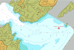
Correction: AC 5621D CaolasAnnraidh, Sound of Iona We have received a report of an unmarked rock of less than 1m depth to the NE of the channel. Its reported position is shown in red on the chart below.
Cautions arising from our 2026 surveys: none as yet (please advise us of anything you spot)
The 2025 set of charts has been superseded by the 2026 set of 814 charts of over 800 locations. We recommend that you no longer use the 2025 or earlier sets: many of the 2025 charts have been subject to changes that make continued use of the originals undesirable.
Many of our cautions have led to corrections to UKHO charts but in case you have older official charts the full lists are available below:
For all cautions arising during 2025 tap here
For all cautions arising during 2024 tap here
For all cautions arising during 2023 tap here
For all cautions arising during 2022 tap here
For all cautions arising during 2020-21 tap here
For all cautions arising during 2018-19 tap here
For all cautions arising during 2017 tap here
For all cautions arising during 2016 tap here
For all cautions arising during 2015 tap here
For all cautions arising during 2014 tap here
For all cautions arising during 2013 tap here.
For all cautions arising during 2012 tap here.
NB Hydrographic surveying and cartography are not precise sciences. There will be errors and misrepresentations on our charts just as there are on others’ charts. Do read the sections on ’Making the charts’, ’Using the charts’ and the ’Conditions’. Take great care at all times but especially if away from the routes described by the pilot books or if your vessel has an unusually deep draught of more than 2.5m.
NOTE: This website and material obtained from it are the copyright of Antares Charts © and may not be reproduced in whole or in part without express consent; use of all such material is subject to the disclaimers and conditions posted on this website and which may be changed at any time. For full Conditions tap here.
|
|
Corrections & Cautions |


|
HOME |
OUR CHARTS |
CORRECTIONS |
GUIDES & HELP |
CONTACT |