
|
Antares charts |
|
Very Large scale wgs 84 electronic charts |


|
Google earth user guide |
|
NOTE: This website and material obtained from it are the copyright of Antares Charts © and may not be reproduced in whole or in part without express consent; use of all such material is subject to the disclaimers and conditions posted on this website and which may be changed at any time. For full Conditions Tap here.
|


|
If you have not previously used our charts in Google Earth see the Setting Up guide
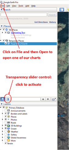
· In Google Earth, go to File (top left) and Open and then select the Antares Chart you wish to open and click on it. · In Google Earth it will appear in the left hand margin in ‘Temporary Places’ but you can save it to ‘My Places’ if you wish and then you will be able to refer to it whenever you want. · The charts may appear distorted: the degree of distortion will vary as you move them around, but the same is true of the underlying land or sea. · Another alternative is just to go to the chart you want, in the ‘KMZ’ chart folder that you have downloaded and unzipped, RIGHT click on it, select ’Open with’ and then ‘Google Earth’. · If you play with the transparency slider (left hand margin of Google Earth, below Places and above Layers ‘Adjust Opacity’) you can, in some cases, see some of the underwater rocks that we have charted... To activate the slider click on the square icon next to the magnifying glass and then on the slider, towards the right of the panel, dragging it slowly to the left.
|
|
HOME |
OUR CHARTS |
CORRECTIONS |
GUIDES & HELP |
CONTACT |
|
SETTING UP AND UPDATING GUIDES |
GUIDES TO USING THE CHARTS
|
PRINTABLE CHART LISTS AND MAPS |
GENERAL Q & As |
ACKNOWLEDGEMENTS & OTHER LINKS & DOWNLOADS
|
|
MEMORY-MAP |
OPEN CPN |
GOOGLE EARTH |
SEACLEAR |
|